
This is the second part of a four-part trip report. To start at the beginning, click here.
Day 4:
Personal Sunrise 7:59 am
Personal Sunset unknown (cloudy)
Today was an exciting day - a time to redeem our long term planning. I'm speaking, of course, of collecting one of my food caches. We hit the Thunder River trail, dropped our packs and headed up to the rim. My cache hadn't been disturbed, other than a hole chewed through my note by a mouse. Most importantly, the beers were still intact! We walked back down the trail, and I had no pack and a beer in my hand. This was the only moment during the hike that I really wanted to meet another backpacker out there, just to see the reaction.
 |
| Good thing the mouse read my note and left my food intact! Or maybe he chewed through it out of frustration after being thwarted by the paint cans? |
We returned to our packs and continued along the Esplanade, this time on the Thunder River trail. Having a trail made the walking a lot easier; especially avoiding the Cryptobiotic soil that is so prevalent in this part of the Canyon. Beautiful stuff.
 |
| This part of the Canyon is full of beautiful, delicate Cryptobiotic soil. |
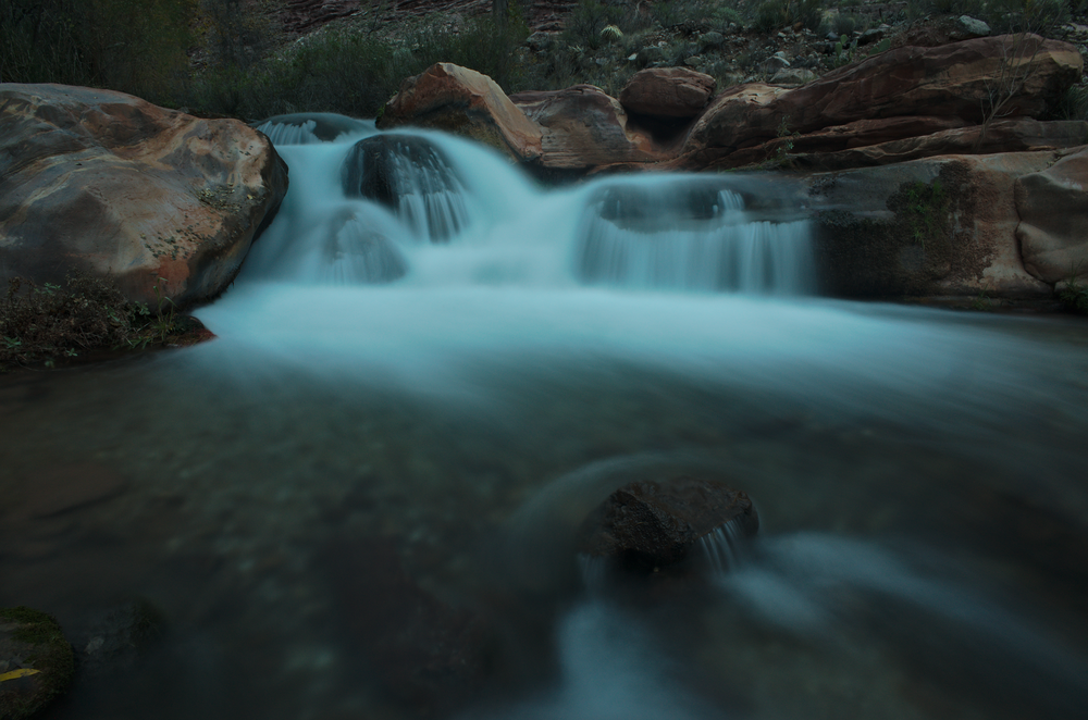
We made it to the edge of the Esplanade platform and started down the trail to Surprise Valley. Surprise Valley was formed when a huge block of rock slide down into the Colorado River, turning as it went. From the junction in the valley we turned left to head towards Thunder River, our site for the night. I had never been there before, and I'm glad we got to include it in our route. From the middle of a cliff (in the Muav Limestone), the water comes pouring out of the rock to form a waterfall, which cascades down the slopes below. Absolutely beautiful. It also has the dubious distinction of being a River which flows into a Creek, which flows into another River, which does not reach the Ocean.
 |
| Thunder River. |
We camped at the Upper Tapeats Camp, just below the confluence of Thunder River and Tapeats Creek. As impressive as the river is, it's not even the main source of the creek - Tapeats Cave, farther upstream, supplies an even stronger fountain of spring water. The combined flow lulled us to sleep that night, until we were woken up by rain and had to bail into the tent. 57 miles to Christmas.
 |
| Tapeats Creek |
Day 5:
Personal sunrise 2:06 pm
Personal sunset 4:20 pm
After a full night of rain, during which rats tunneled through Snickers bars in Craig's pack, we had a decision to make - continue up our original route, up Tapeats Creek and Saddle Canyon? Bypass Tapeats above the Tonto but still do Saddle? Or do the true backup plan, hike back up to the Esplanade and contour above the Supai around to Muav Saddle? The first plan would go, but guarantee us getting soaked in the narrows of Tapeats Creek. The second plan avoided that section, but Saddle Canyon would definitely still have some wading. And the third definitely was possible, but we had no beta on it and were pretty sure it would involve some tough bushwacking.
We figured that we were well equipped to deal with snow, rain, or any other form of precipitation we were likely to deal with. We also had an extra day's worth of food in case the route proved more difficult than anticipated. And we are both very experienced with bushwacking. Given the recent rain and the fact that every pool in Saddle Canyon was surely full to the brim, we decided to go for option 3 and head back up to the Esplanade that night. First, however, we decided to take a side trip to Deer Creek.
 |
| The beginning of the Deer Creek narrows |
Deer Creek is another stunning jewel of the desert, a gorgeous spring-fed slot canyon. The trail takes you from Surprise Valley, past one of the sources of the creek, and then down creek to where the slot begins. Once the canyon bottom drops away, the trail follows ledges in the upper part of the slot.
 |
| Careful . . . |
After Deer Creek we headed back up above Surprise Valley to the top of the Supai to camp for the night. At first, it looked like it was going to clear up for the night, and I was able to get one milky way shot in, but then the clouds moved in. Which isn't always a bad thing after a rainy day, since cloud cover keeps the nights from being too cold. The next night we wouldn't be so lucky. 53 miles to Christmas.

Day 6:
Personal sunrise 2:06 pm (again!)
Personal sunset 5:08 pm
Snow, sleet and sun alternated all day. We were contouring on the Esplanade, but the sandstone quickly petered out and was replaced with bushwacking, of increasing intensity. We were leaving the wide sandstone expanses of the western Grand Canyon and heading towards the land of heinous bushwacks - high drainages on the North Rim drainages. The elevation of the Esplanade increased as we were heading up the Kaibab Upwarp, and the microclimate began to shift towards a wetter one that favored such plants as manzanita, scrub oak and cliff rose. They are beautiful plants, and I'm particularly fond of manzanita. But the abrupt shift from easy sandstone walking was a rough one. We tried to take the path of least resistance, but by the end of the day our shoes were soaked from the snow and our shins were battered from pushing aside manzanita branches. Craig even had a pocket ripped open and his knit hat ripped out. For the rest of the trip, he would borrow either my fleece hat or my balaclava, whichever I wasn't using at the time.
 |
| A rare moment of easy walking. |
Fighting our way through the brush, we headed the tributaries of the Tapeats Cave drainage, then headed down into Crazy Jug Canyon and out a tributary on the other side. By the end of the day, we had our bushwhacking heads back on and were finding better paths through the brush, but it was still tough going. The drainage crossings were the worst, filled with oaks and snow in the bottom and on the north-facing sides. Our goal was to cross Timp Canyon and camp on the other side, to hopefully ensure that we would make it past Muav Saddle and down to lower elevations on our next night. By the time we got to Timp it was after 4 pm, but the sun had come out and Timp turned out to be one
of the easier drainages to cross, so we made it with time to enjoy the sun setting behind Mt. Trumbull.
 |
| The sun setting across Timp Canyon. |
As we ate dinner, we noticed that the clouds had cleared up all over the sky. It looked like a front might be moving in, clearing them away. Good news for tomorrow, but bad news for tonight. Without a thermal blanket above us, the earth radiated away its energy quickly, and the cold set in. The clearest sign of this came from my sleeping bag, which had gotten slightly damp during the day. While I was still eating dinner, a little before 6pm, that water was turning to frost! We quickly moved every damp or loose item under or inside of a pack, "to prevent frosting". Too bad we didn't have a cake. 44 miles to Christmas.
Day 7:
Personal sunrise 8:35 am
Personal sunset 3:18 pm
 |
| Sunrise from my sleeping bag |
What a long day. 8 miles as the crow flies, much longer by our route. We woke up to beautiful blue skies, a gorgeous sunrise, fog in the distance below Mt. Trumbull, and shoes frozen solid. Thankfully the shoes thawed rather quickly once we started walking. We had three major drainages to cross. Stina Canyon was the biggest, and we contoured into it on a nice patch of Esplanade to plan our attack. By now we had gotten better at this and were able to find a way down, a nearly brush-free crossing right above a pour-off, and then a scramble up the other side. A little foresight goes a long way when you're battling oaks.
 |
| Sunrise a few minutes later |
We continued up to Muav Saddle on the eastern slopes above Saddle Canyon. The drainage crossings were full of scrub oak and the occasional new mexican locust, but most of the hiking was in juniper/manzanita country, with the occasional pinyon, agave or prickly pear. I really enjoy this kind of bushwhacking - enough challenge to keep it interesting, but not enough to get frustrating. And after the day before I was fully in the zone and prepared for it. It puts one in a unique headspace; mind occupied simultaneously by your route on multiple scales. You need to pay attention to your immediate steps: avoiding that prickly pair, for instance. And you need to look ahead for paths of least resistance through the vegetation, connecting them to each other and forming hypothesis about what might lay ahead. Finally, you have to make sure you're meeting your general goals of where you want to get to - contouring and maintaining elevation, heading up to a saddle, entering or leaving a drainage, etc. With my mind occupied by all of these things, I feel fully present in the landscape.
 |
| Manzanita. 'nough said. |
As we ascended through the brush, we kept thinking we would drop into Saddle Canyon, but the slopes on the east side kept presenting us with better alternatives. The junipers gradually gave way and we were walking through knee to waist high manzanita. The day before this would have frustrated me, but with the right head on my shoulders I just slowed down slightly, gave the branches their due respect, and passed through the gauntlet relatively unscathed. Working with and around the manzanita, rather than against it, makes a huge difference. And it sure as hell beats fighting locusts up a drainage.
Finally, however, the good manzanita ran out and we dropped into Saddle Canyon just after Powell Spring. The drainage was easier than we expected, with the occasional oak or locust to avoid, but no thickets. And best of all, we were entering ponderosa pine country. These were big, old-growth ponderosas, most of them at least 3 feet wide. These old trees have a yellow-red bark and are called "yellow-bellies". They also have an amazing smell to them, like butterscotch or vanilla. I made sure to stop and put my nose in between the bark of the bigger ones.
 |
| Heading up the Saddle Canyon drainage in the snow |
Up on Powell Plateau, just a short walk from Muav Saddle, lies an even larger grove of yellow-bellies. Protected from logging by the relative difficulty of accessing them, they remained unscathed. Up there, every tree is a yellow-belly, and when you top out on the plateau the entire place smells of butterscotch. If there had been less snow on the ground we would've made the side trip up there, but we wanted to ensure that we camped down lower to have a warm night.
We got to the patrol cabin below Muav Saddle at 2pm. This was used by Teddy Roosevelt back when he was hunting cougars on the Plateau, and now is used occasionally by backcountry rangers. It contains a register, and as is my way when I encounter a register, I added a haiku:
Snow makes great TP
Forty miles to Christmas
There's beer at the Ranch
 |
| The PEAKS! |
After reading and writing in the register, we headed up to the Saddle, and I could see the San Francisco Peaks! It was great seeing a little slice of home. This was the mental crux of our trek, and we had been dreading the snow for the previous couple of days. It was also the halfway point, in terms of time. So it was great to be over the hump and headed down. This was our second scenic divide - we said our goodbyes to the Esplanade for good, and headed down the North Bass Trail. Having a trail made a huge difference in our time, and we got all the way below the Redwall and out onto a campsite on the Tapeats sandstone before dark. Craig had the quote of the day on the way down: "It's nice to be walking through the manzanita, without walking through the manzanita".
No comments:
Post a Comment